Space technology deployment expands in J&K for disaster management, planning and research: Centre
ISRO tools support flood mapping, forest fire alerts, and decentralised development planning New Delhi: Space technology is being increasingly deployed in Jammu & Kashmir for disaster monitoring, damage assessment, and
ISRO tools support flood mapping, forest fire alerts, and decentralised development planning
New Delhi: Space technology is being increasingly deployed in Jammu & Kashmir for disaster monitoring, damage assessment, and evidence-based planning across sectors, the government said in Parliament.
In a written reply in the Rajya Sabha on Monday, Union Minister of State for Space, Science and Technology Dr Jitendra Singh said geospatial inputs are being actively used to track and respond to natural disasters such as floods, landslides, and forest fires in the Union Territory.
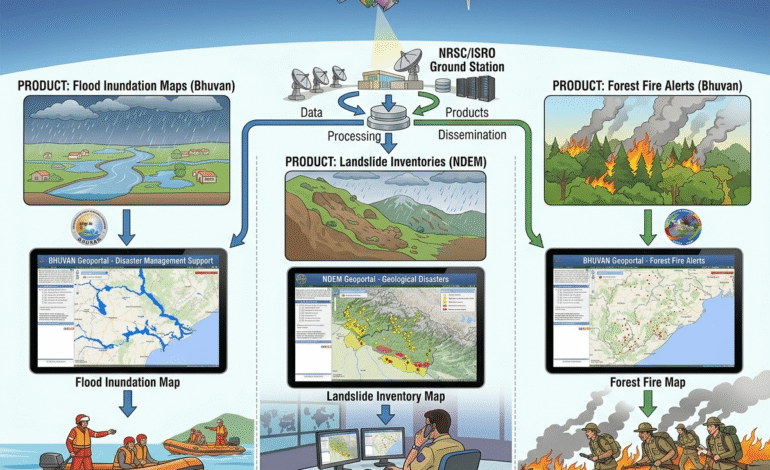
Satellite-based products including flood inundation maps, landslide inventories, and forest fire alerts are disseminated through ISRO geoportals such as Bhuvan and the National Database for Emergency Management (NDEM). A customised mobile application and dashboard have also been developed to support forest fire reporting for the J&K forest department.
ISRO, in collaboration with the J&K Remote Sensing Application Centre, is implementing multiple space application programmes covering natural resource census, wetland inventory, biodiversity mapping, and land degradation assessment.
The Space-Based Information Support for Decentralized Planning (SIS-DP) update programme is also being used to support data-driven planning in sectors such as agriculture, forestry, rural development, and watershed management.
To strengthen research and academic engagement, the Satish Dhawan Centre for Space Science has been established at the Central University of Jammu, providing students and faculty access to ISRO facilities.
At the regional level, space technology incubation and academic support programmes are being extended through centres such as the Space Technology Incubation Centre at NIT Jalandhar and the Regional Academic Centre for Space at NIT Kurukshetra, enabling students across northern India, including J&K, to work on ISRO-linked projects.
The RESPOND programme further allows academic institutions nationwide to participate in sponsored research projects in space technology.
The government also highlighted the role of the National Database for Emergency Management under the Integrated Control Room for Emergency Response of the home ministry. The platform integrates satellite-based inputs with alerts from agencies such as IMD, Central Water Commission, and Defence Geoinformatics Research Establishment, and provides decision-support tools for emergency response and post-disaster assessment.
The minister said these initiatives are enhancing disaster preparedness, improving coordination, and enabling technology-driven governance in Jammu & Kashmir.