Space Tech Embedded Across 63 Ministries, 36 States; ISRO Expands Role in Agriculture, Disaster Response and Climate Monitoring
In a written reply in the Lok Sabha, Minister of State for Science and Technology Dr Jitendra Singh outlined how satellite data and indigenous space platforms are now operationally integrated into flagship programmes of central ministries and state governments.
New Delhi: Space-based systems developed by the Indian Space Research Organisation (ISRO) and the Department of Space (DoS) were extensively deployed in 2025 to support agriculture, disaster management, climate monitoring and major welfare schemes, the government informed Parliament on Wednesday.
In a written reply in the Lok Sabha, Minister of State for Science and Technology Dr Jitendra Singh outlined how satellite data and indigenous space platforms are now operationally integrated into flagship programmes of central ministries and state governments.
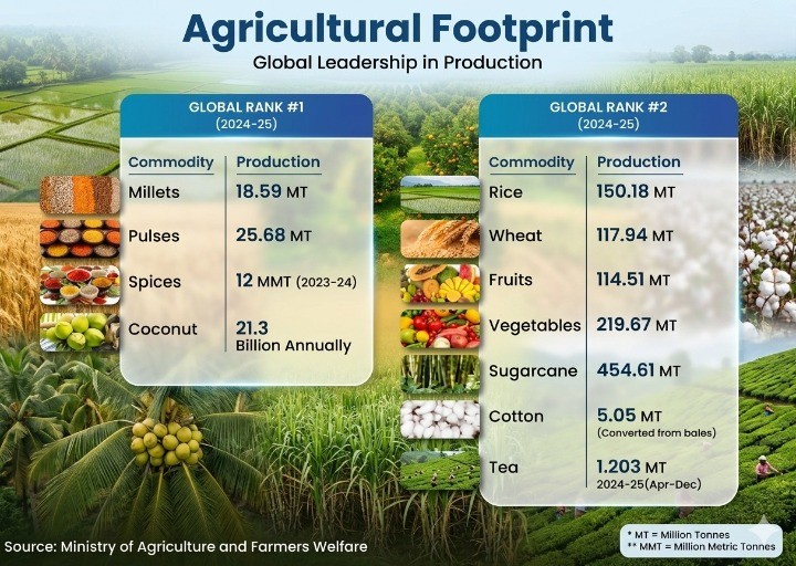
Agriculture: From Crop Mapping to Insurance Settlements
Satellite-based monitoring has scaled up significantly in agriculture. ISRO conducted all-India in-season crop sown and harvest area mapping across all three crop seasons, along with national mapping of Kharif rice, wheat and jute. National-level yield estimation for rice and wheat was also undertaken.
At the state level, detailed crop mapping was carried out for Maharashtra (soybean, cotton, paddy) and Madhya Pradesh (soybean, wheat, gram, mustard, paddy). Importantly, insurance unit-level yield estimation was conducted in nine states to support claim settlements under the Pradhan Mantri Fasal Bima Yojana (PMFBY).
Satellite data is now operationally used under PMFBY for crop mapping, yield estimation and damage assessment, reducing reliance on manual surveys and improving transparency.
A dedicated Jute Crop Information System has also been developed to strengthen crop intelligence for the fibre sector.
Disaster Management: Real-Time Monitoring and Early Warnings
Space-based applications played a critical role in disaster preparedness and response during 2025. ISRO provided operational flood early warning services in parts of the Brahmaputra, Godavari and Tapi basins, and mapped flood-affected areas during major flood events.
Regular monitoring of glacial lakes was carried out to assess potential outburst risks, while a Satellite Integrated Landslide Assessment and Alert System was operationalised.
Lightning nowcasting using data from the Light Detection Sensor Network and IRS meteorological satellites, supported by artificial intelligence, has added a predictive layer to extreme weather response.
These outputs are operationally utilised by the National Disaster Management Authority, state disaster management authorities and the ministry of home affairs.
Climate Monitoring: From NO₂ Tracking to Carbon Budgeting
ISRO also expanded climate-focused satellite applications in 2025. These include satellite-based monitoring of nitrogen dioxide concentrations over thermal power plants around Delhi to assess their contribution to air pollution.
A GeoAI framework for air quality monitoring over the Indian region has been developed. The agency also quantified greenhouse gas emission inventories for land use and land use change, and carried out inter-annual budgeting of tropospheric CO₂ over the Indian monsoon region using model diagnostics and satellite and in-situ datasets.
Biennial land cover and land use change datasets derived from satellites are being used by the Ministry of Environment, Forest and Climate Change for National Communications under UNFCCC commitments. Indian Remote Sensing satellite data is also used by the Forest Survey of India to generate the India State of Forest Report.
Space in Welfare Delivery and Infrastructure Monitoring
Satellite and geospatial platforms are now embedded in several major welfare schemes.
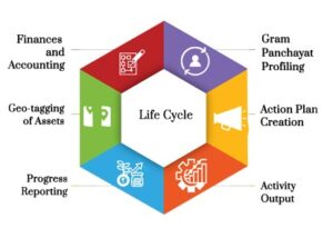
Geospatial planning portal Yuktdhara is being used by rural development departments across all states for scientific planning of MGNREGA works. High-resolution satellite data is operationally deployed to monitor interventions under Watershed Development Component–Pradhan Mantri Krishi Sinchayee Yojana 2.0.
Space-based monitoring also supports progress tracking under Pradhan Mantri Awas Yojana–Housing for All (Urban) and mapping of rural road networks under Pradhan Mantri Gram Sadak Yojana. Assets created under Rashtriya Krishi Vikas Yojana are also being monitored using geospatial technologies.
Ocean, Weather and Strategic Integration
Indian meteorological and ocean-monitoring satellites are operationally integrated at the India Meteorological Department and the Indian National Centre for Ocean Information Services (INCOIS), supporting cyclone monitoring, fisheries advisory, ocean state forecasting and coastal management.
The Indian Navy assimilates satellite data for weather and ocean outlook through a dedicated portal, MOSDAC-IN. Sea ice advisories are used by the National Centre for Polar and Ocean Research to plan safer navigation during Antarctic scientific expeditions.
Global Leadership in Disaster Response
India completed its six-month leadership tenure (April–September 2025) of the International Charter Space and Major Disasters, during which 39 disaster response activations were executed globally. Four new authorised users were onboarded, extending space-based disaster support to additional developing nations.
Open Data and National Mission Planning
To enhance accessibility, the government provides open and free access to Indian Earth Observation data with Ground Sample Distance coarser than 5 metres under Indian Space Policy-2023. Data finer than 5 metres is supplied free to government users and at fair pricing to non-government entities.
Near-real-time products are disseminated through portals such as MOSDAC and VEDAS, while training programmes and workshops are conducted to build capacity among operational users.
National Meet 2025 (NM2.0), held on August 22 in New Delhi under the theme “Leveraging Space Technology & Applications for Viksit Bharat 2047,” compiled current and future requirements from 63 ministries/departments and 36 states/UTs through more than 300 one-to-one consultations. A National Mission Plan has been generated to service these requirements.
The parliamentary reply underscores that satellite data and indigenous space platforms are no longer confined to research missions but are now embedded in governance, infrastructure planning, environmental compliance and disaster response—positioning space technology as a core enabler of India’s development trajectory.